Earthquake damage to land and infrastructure alongside the Heathcote River has led to increased severity of flooding.

Get updates on flood mitigation in the Heathcote River area.

Heathcote catchment

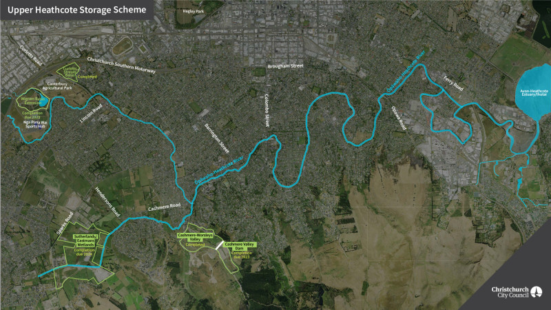
Upper Heathcote storage basins

A series of stormwater basins in construction in the upper Heathcote are helping to reduce flood risk, improve water quality and provide new public recreational spaces.

Upper Heathcote storage basins

A series of stormwater basins in construction in the upper Heathcote are helping to reduce flood risk, improve water quality and provide new public recreational spaces.

Changes caused by the earthquakes have increased flood risk along the Heathcote River. One of the key ways we can reduce flood risk is to store water during the peak of storm events, and slowly release the stored water after water levels downstream have dropped.

This results in a lower peak river level and reduces the risk of flooding for homes in the upper and mid-Heathcote which have an increased risk of flooding as the result of the earthquakes.

The flood management basins are combined with treatment wetlands to help improve water quality by treating stormwater runoff and sediments. The wetlands are also providing recreational areas with walkways and cycleways, grassland, wetland and forest habitats.

Upper Heathcote storage optimisation

To best manage the risk of river flooding and to optimise the benefits provided by the basins we’re installing automatic control gates to capture and release flood flows from the four basins.

Radio communications will also be provided to connect the system back to the control room at the Christchurch Sewage Treatment Plant.

Work is underway to integrate the four individual basin control systems in the Upper Heathcote River catchment and to minimise downstream flood levels for the design rainfall events.

Basins completed

Curletts Stormwater Basin

The Curletts Stormwater Basin at 201 Annex Road has been constructed. Capable of holding up to 130,000m3 of water, it is designed to provide additional flood protection up to a 1-in-50 year rainfall event.

It also treats water within Curletts Stream to remove sediment and contaminants to improve water quality in the stream and the Ōpāwaho/Heathcote River.

The basin is planted with wetland plants and the surrounding areas are planted extensively with native trees and shrubs. The area is accessible to the public from Mokihi Gardens and Annex Road, providing a lovely new space for walking.

Wigram East Basin

Wigram East Basin in Canterbury Agricultural Park has seen the lowering of a large area of the park for flood storage and created four hectares of wetland.

In a one-in-100 storm event, the basin can now store around 520 million litres of water, the equivalent of 236 Olympic-sized swimming pools, which means less risk of properties along the upper reaches of the Heathcote flooding.

The new wetland area provides habitat for a number of threatened species and also helps to clean the water as it leaves the basin and flows into the Heathcote.

As part of the flood protection work an extra kilometre of the walking track has been added to the park.


Ongoing works

Sutherlands Hoon Hay Eastman Wetlands storage basins

This 100ha stormwater facility is being constructed on a large area of low-lying land between Sparks, Sutherlands and Cashmere Roads. 

During large flood events, two flood control gates will hold back approximately than 600,000 m³ of stormwater and will control its release into Cashmere Stream and the Heathcote River, helping to reduce flooding downstream.

In addition, wetlands will treat the stormwater run-off from the surrounding urban developments during normal rain events, and reduce sediment discharged from the Hoon Hay Valley.

The spring-fed Cashmere Stream runs through the facility, and this section of the stream is being enhanced as part of the project.  This project is co-funded by Council and the Ministry for the Environment Freshwater Improvement Fund. 

Across the whole facility, we are expecting to plant over 100,000 native tree species and 600,000 native plant species which will provide stormwater treatment and improve biodiversity and habitat. An extensive network of 11km of public access paths and tracks is being built which will provide a great space for the community to enjoy.

Construction is being undertaken in stages and will be progressively opened to the public over the next few years. The first stage of the facility south of Cashmere Stream is anticipated to be open to the public by the end of 2022.

Cashmere Worsleys flood storage basin

The Cashmere and Worsleys Valleys have been identified as good places for basins that will reduce flood risk to properties around the lower and mid-Ōpāwaho/Heathcote and improve water quality in Cashmere Stream and the Ōpāwaho/Heathcote River.

The first stage of the project is completed and is a structure in Cashmere Valley Drain, close to Worsleys Road, which can be shut to store water in the lower part of the valley.  This will allow the lower valley to hold up to 500,000 m³ of water, and is designed to provide additional flood protection up to a 1-in-50 year rainfall event.

The valley has also been contoured to allow as much sediment as possible to settle out prior to water leaving the valley. This will improve water quality in Cashmere Stream and the Ōpāwaho/Heathcote River.

The second stage of the project will be to construct a dam in the upper part of the Cashmere Valley to provide an additional 300,000 m³ of water. This stage of the project will begin construction in the second half of 2022.

In addition to the flood control works extensive wetland planting is underway in both the upper and lower basins, along with construction of a network of paths for recreational use. Planting the valleys increases sediment capture while also increasing habitat diversity.

Dredging

Dredging work on the lower Ōpāwaho/Heathcote River to help lower the risk of flooding in the area.

Dredging work began on the lower Ōpāwaho/Heathcote River in 2018 to help lower the risk of flooding in the area and is now complete.

The dredging helps to restore river capacity lost after the earthquakes by removing silt deposits.

The dredging has also removed contaminated sediment which has entered the river from commercial and street stormwater runoff, which has improved the in-stream habitat in the river.

This complements benefits from the new stormwater filter at nearby Richardson Terrace.

Bank stabilisation

Bank stabilisation work is to counteract erosion and slumping which has reduced river capacity.

Some sections of the bank along the Heathcote River suffered damage from the 2010/11 Earthquakes. Erosion and slumping reduced the river capacity and increases the impact of frequent flooding. It also increases the risk to adjacent roads and other infrastructure.

The Council undertook significant bank stabilisation works, increasing the waterway area by widening the channel wherever possible. A naturalised bank profile has been formed, rather than hard engineering structures.

The river will undoubtedly find new unstable sections of the bank to erode and the completed works won’t stop this, but they will reduce the number of reactive repairs required.

We also now have a good working knowledge of construction methods which will help with future bank stabilisation work.

Landscape planting, rock edging and eel hides also help to provide new habitats and increase ecological diversity along the river corridor.

Flood intervention policy

Council's approach to flood intervention in the area.

In 2015, the Council introduced the Flood Intervention Policy(external link), to help property owners who've had frequent above-floor flooding, where their flooding has been worsened by the earthquakes and planned flood mitigation schemes will not offer a timely reduction to their flood risk.

The Council works with these property owners to determine the most appropriate, cost-effective option for their property, which might be reducing their flood risk through localised drainage works or house raising, or the Council may offer to purchase the property. Purchase offers are voluntary.

The application of this policy along the Heathcote River is now complete.

Low stopbanks

Following severe flooding along the Ōpāwaho Heathcote River in July 2017, Christchurch City Council resolved to investigate the technical feasibility of installing low stopbanks along the river between Colombo Street and Radley Street to reduce the flood risk.

The stopbanks were one part of a comprehensive suite of floodplain management works.

Those investigations have found that while it is technically feasible to install low stopbanks for frequent smaller flood events, it is not feasible to install stopbanks for large flood events.

Low stopbanks are considered to be a low priority for flood management in the Heathcote, with no funding in the 2021-2031 section of the Council’s Long Term Plan (LTP) and with no allocation in the LTP until 2041.

Based on those findings and the absence of LTP funding, Council staff are now recommending the Council not proceed with the stopbank project and remove it from the LTP.

The floodplain management work the Council has done since 2017 has substantially lowered the flood risk along the Ōpāwaho Heathcote River and built low stopbanks - at a cost of between $22 million and $58 million - may not deliver the benefits sought.

Low stopbanks may be identified in future as an appropriate response to flooding when considered in the context of a range of possible floodplain management projects and climate adaptation measures, including policy approaches.

Floodplain management and low stopbanks webinar

Watch the recording of the Heathcote River Floodplain Management and Low Stopbanks webinar recorded on July 14 2022. 

Check out our frequently asked questions [PDF, 330 KB] and the webinar slides [PDF, 3.9 MB]


Wider catchment areas

Matuku Waterway - Heathcote Valley

Matuku Waterway flood mitigation works have been completed.

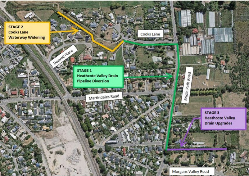
Land Drainage Recovery Programme work on Matuku Waterway has reduced flooding in Heathcote Valley downstream of Bridle Path Road. The work included:

  • Construction of a stormwater pipeline, beginning at the Heathcote Valley Drain inlet and finishing in Cooks Lane. The pipeline diverts stormwater flows from Heathcote Valley Drain in Morgan's Valley to the lower Matuku Waterway in Cooks Lane, reducing flood risk to nearby properties.
  • A section of Cooks Lane Waterway has been widened to accommodate the diverted flows. Replanting has been done in the reserve area between Cooks Lane and Deavoll Place.
  • Heathcote Valley Drain has been rock-lined to prevent further erosion and reduce the risk of water overtopping the drain inlet.
Matuku Waterway works

Matuku Waterway works

Bells Creek - Woolston

The Bells Creek flood mitigation scheme is now operational, bringing reduced flood risk, improved water quality and new recreational spaces.

Bells Creek

The Bells Creek flood mitigation works have reduced above-floor flood risk for 32 properties, improved the quality of water going into the Ōpāwaho /Heathcote River and brought new community recreational spaces. The $19M scheme, completed in May 2019, includes:

  • The Richardson Terrace Stormwater Pump Station and Stormwater Filter - The pump station near the corner of Richardson Terrace and Ferry Road helps to lift floodwater out of the Bells Creek
  • catchment into the Ōpāwaho/Heathcote River. Within the same facility, the new stormfilter - Australasia’s largest - also treats most stormwater before it flows into the Heathcote. 
  • Te Oranga Waikura Urban Forest (external link)and stormwater basin - A stormwater basin and urban forest, with more than 16,000 trees planted.
  • Edmonds Park Basin and Bells Creek realignment - Edmonds sports field was excavated by approximately one metre to form a stormwater storage basin. A pump station and under drainage was installed to improve drainage of the basin and sports fields. The area is now dual-use, with the park flooding only in large rainfall events, and otherwise still operates as sports fields. Bells Creek was also realigned and naturalised through Linwood College, to deliver water to the basin, and provided the school with additional area to build on.
  • Upgrade of pipes in the Mackworth Street area.